Blog Naheem

Scroll and enjoy content from my exploration of Geospatial data analysis and Software Development

Feature

Reading and plotting raster data with Rioxarray

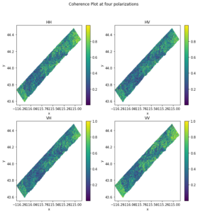
Rioxarray is a python package that is built upon xarray and rasterio packages to facilitate the analysis of raster or xarray datasest. In this article, I show an example of how I read and visualize raster data using rioxarray. This

Read More
Uncategorized

The role of imaging in Geodesy: Monitoring shape and motion

Geodesy is the science of measuring the orientation, shape, size and gravity of the earth as well as the variation of these properties over time. Conventionally, these measurement is done using various surveying and astronomical equipment such as levelling, GPS,

Read More
Feature

An overview of Interferometry SAR (InSAR)

SAR data contains Amplitude Α and Phase Ø. Amplitude is the backscatter which depends on surface roughness and dielectric constant of the scatters. In Interferometric SAR (InSAR) we are work with phase variation.  Phase is the fraction of  a fully

Read More
SAR

Geometric and Radiometric Properties of SAR

The side looking property of  radar systems, surface slopes and other terrain features causes geometric and radiometric distortion in image data acquired by SAR systems. The geometric distortion are foreshortening and layover. The radiometric distortion results in shadow. If a

Read More
SAR

Synthetic Aperture Radar

In one of the previous posts, I discussed the principle of Side Looking Airborne Radar (SLAR) systems. In that article, we established the formula for the azimuth resolution of SLAR systems as: PA = λR/L = λH/L cosØ = βH/cosØ

Read More
SAR

Side Looking Airborne Radar (SLAR) System

Besides the crucial merit of all-day and weather observation capability, radar systems interact with earth features differently than other imaging systems thereby providing additional information that would otherwise be impossible to derive. While optical and thermal sensors records the solar

Read More

Accessing and downloading topography data

There are many platforms to download DEM and other topography data. One platform that I found very useful is open topography. There are huge varieties of topography dataset such as high resolution topography data, point cloud data, global and regional

Read More

Serendipity

The first time I heard of the word was during a business Orientation program by the CEO of tantalizer. Since then, I had thought of writing something relating to the ‘ three princes of serendip’ who were always making discoveries

Read More

History of Radar

Although the application of radio detection and ranging (RADAR) in detecting objects began in the 20th century, the history of radar dates back as far back the development of electricity, magnetism and electromagnetism. In 1780, Italian physicist Luigi Galvani and

Read More
Feature

SAR 1.0 : Basics of Radar Imaging

Radar stands for Radio Detection and Ranging. A radar measures the range or distance to an object by transmitting an electromagnetic signal to an object and receiving the echo reflected by the object. Since electromagnetic waves travels at the speed

Read More

Suggest Edit or Review?

drop me a line and get in touch