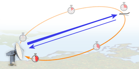
Radar stands for Radio Detection and Ranging. A radar measures the range or distance to an object by transmitting an electromagnetic signal to an object and receiving the echo reflected by the object. Since electromagnetic waves travels at the speed of light, we only need to measure the the time it takes the signal to transmits to the object and back to the radar to calculate the range to the object. The total distance is twice the the range between the radar and the object since the signal travels from the radar to the object and reflected from the object back to the radar. So, we can calculate the range after measuring the two-way travel or propagation time, t.
R = ct/2
Where c is the speed of light. The factor ½ account for the-two way travel of the signal- from the radar to the object and from the object back to the radar. If the propagation medium is different from vacuum, we have to estimate the actual propagation velocity for advanced techniques such as Synthetic Aperture Radar (SAR) Interferometry.
Radars provide their own signal to detect the presence of objects so they are referred as active remote sensing equipment. Since they have their own signal, they can operate at any time, day and night. In addition to all-time operation, radar signal can also penetrate clouds and rain so they are referred as all-weather equipment. Remote sensing radars such as SAR provide high resolution images of the earth. Using appropriate analysis techniques and model, geophysical information can be derived from these high-resolution images.